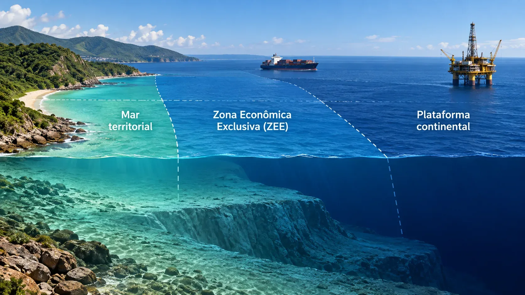
The territorial sea, exclusive economic zone (EEZ), and continental shelf are not three belts in which a country exercises the same kind of authority. The main difference is the object of the legal right. In the territorial sea, the coastal State exercises sovereignty over the waters, airspace, seabed, and subsoil, subject to the United Nations Convention on the Law of the Sea (UNCLOS), including the right of innocent passage for foreign ships. In the EEZ, there is no full territorial sovereignty: the coastal State has sovereign rights over resources and specific areas of jurisdiction. On the continental shelf, the legal focus is the seabed and subsoil.
Quick comparison of the three zones
| Zone | Basic conventional limit | Main right of the coastal State | What remains for other States |
|---|---|---|---|
| Territorial sea | Up to 12 nautical miles from the baselines | Sovereignty over waters, airspace, seabed, and subsoil | Innocent passage of ships under UNCLOS |
| EEZ | Up to 200 nautical miles from the baselines | Sovereign rights over resources and jurisdiction in matters defined by UNCLOS | Navigation, overflight, and laying of cables and pipelines, among other uses compatible with the Convention |
| Continental shelf | Seabed and subsoil beyond the territorial sea, at least to 200 nautical miles and, when Article 76 criteria are met, beyond that | Exclusive rights to explore and exploit resources of the seabed and subsoil | The legal status of the superjacent waters and airspace is not changed by shelf rights |
Territorial sea: sovereignty, but not an absolute closure of the sea
Part II of UNCLOS provides that the sovereignty of the coastal State extends to the territorial sea and also to the airspace above it, its seabed, and its subsoil. Each State may establish a territorial sea up to 12 nautical miles wide, measured from the baselines determined under the Convention.
This sovereignty is broader than the rights that exist in the EEZ. Even so, it does not mean that the State may treat the territorial sea as if it were land territory closed to foreign navigation. UNCLOS recognizes the right of ships of all States to innocent passage, provided that passage is continuous and expeditious and is not prejudicial to the peace, good order, or security of the coastal State.
The accurate description is therefore sovereignty exercised subject to applicable international law. The coastal State has strong territorial powers, but the Convention itself defines passage rights and limits on how those powers are exercised.
EEZ: economic rights and functional jurisdiction, not full territorial sovereignty
Part V of UNCLOS treats the EEZ as an area beyond and adjacent to the territorial sea. Its outer limit may not extend beyond 200 nautical miles from the baselines. This does not mean 200 additional miles beyond the territorial sea: the 200-mile measurement also starts at the baselines.
In the EEZ, the coastal State has sovereign rights to explore, exploit, conserve, and manage natural resources, whether living or non-living, of the waters, seabed, and subsoil. The Convention also recognizes rights regarding other economic activities, such as the production of energy from water, currents, and winds.
The coastal State also has jurisdiction, as provided by UNCLOS, over the establishment and use of artificial islands, installations, and structures, marine scientific research, and the protection and preservation of the marine environment.
The decisive point is that these powers do not amount to sovereignty over the entire zone. Other States continue to enjoy freedoms of navigation and overflight and of laying submarine cables and pipelines, as well as other internationally lawful uses related to those freedoms, subject to due regard for the rights and duties of the coastal State.
Continental shelf: the right attaches to the seabed and subsoil
Part VI of UNCLOS defines the continental shelf in legal terms. It comprises the seabed and subsoil of submarine areas extending beyond the territorial sea to the outer edge of the continental margin, or to 200 nautical miles from the baselines where the continental margin does not extend that far.
This creates an essential distinction from the EEZ. The continental shelf is not, by itself, a belt of waters controlled by the coastal State. The rights concern the seabed and what lies beneath it. The coastal State exercises exclusive sovereign rights to explore and exploit the natural resources of the shelf, including mineral and other non-living resources of the seabed and subsoil, as well as organisms belonging to sedentary species as defined by the Convention.
Those rights exist independently of effective occupation or an express proclamation. At the same time, Article 78 states that rights over the continental shelf do not affect the legal status of the superjacent waters or the airspace above those waters.
Why the EEZ and continental shelf can overlap
The three categories should not be imagined as three completely separate legal rings. Within the first 200 nautical miles, the EEZ and continental shelf may coexist over the same horizontal space while regulating different objects.
In the EEZ water column, the coastal State has the sovereign rights and competences established in Part V. On the seabed and in the subsoil, the corresponding rights are exercised under the continental shelf regime in Part VI. UNCLOS itself clarifies in Article 56 that EEZ rights concerning the seabed and subsoil are to be exercised in accordance with Part VI.
An example makes the distinction clearer. Fishing for species moving through the water column is a typical EEZ issue. Oil or mineral extraction from the seabed or subsoil is a typical continental shelf issue. A merchant ship crossing the EEZ is exercising freedom of navigation, not seeking permission equivalent to entering the coastal State's land territory.
When the continental shelf can extend beyond 200 miles
Under certain geological and legal conditions, the continental shelf may extend beyond 200 nautical miles. Article 76 uses criteria related to the continental margin and establishes formulas and constraints for defining the outer limit. General constraints include references to 350 nautical miles from the baselines or 100 nautical miles from the 2,500-metre isobath, with specific rules for certain submarine ridges and elevations.
When a State intends to establish outer continental shelf limits beyond 200 nautical miles, it must submit information to the Commission on the Limits of the Continental Shelf. The Commission makes recommendations, and limits established by the State on the basis of those recommendations are treated by the Convention as final and binding.
This process does not automatically turn the waters above the extended shelf into an EEZ or territorial sea. That is precisely why rights over the seabed and subsoil must be separated from the legal status of the overlying waters.
Distances are measured from baselines
The 12-mile and 200-mile limits are not measured from any point chosen on the beach. UNCLOS uses baselines. In the normal case, the baseline is the low-water line along the coast as marked on officially recognized charts, but the Convention also provides special methods, including straight baselines under specified geographic conditions.
A schematic map is therefore useful for understanding the logic of the zones, but it is not enough to establish an actual legal boundary. The position of baselines, coastal geography, islands, bays, opposite or adjacent coasts, and existing agreements can affect the concrete delimitation.
What happens when two countries' maritime projections overlap
A theoretical 200-mile projection can meet the maritime projection of another State. In those cases, it is not correct to assume that each country simply keeps the full 200 miles. For the territorial sea between opposite or adjacent coasts, Article 15 of UNCLOS provides, absent agreement to the contrary, for a median line, subject to historic title and other special circumstances.
For the EEZ and continental shelf, Articles 74 and 83 provide that delimitation between States with opposite or adjacent coasts is to be effected by agreement on the basis of international law in order to achieve an equitable solution. General explanations of maritime zones therefore do not decide concrete maritime boundary disputes.
How to distinguish sovereignty, resources, and navigation in practice
- If the question concerns territorial control of the water, airspace, seabed, and subsoil close to the coast: the main concept is the territorial sea, up to 12 nautical miles, with innocent passage for foreign ships.
- If the question concerns fisheries, energy, and other resources within up to 200 nautical miles: the main concept is usually the EEZ, which grants economic sovereign rights and specific jurisdiction while preserving freedoms of navigation and overflight.
- If the question concerns oil, gas, minerals, or other resources of the seabed and marine subsoil: the central regime is the continental shelf, including where it extends beyond 200 nautical miles after the legal requirements are met.
The safest way to avoid confusing the three regimes is to ask first which part of the maritime space is at issue: waters and airspace, resources in the water column, or seabed and subsoil. Then identify what kind of authority UNCLOS recognizes: sovereignty, sovereign rights over resources, or specific jurisdiction. This distinction explains why a State may have exclusive resource rights in an area without turning the entire area into national territory and without eliminating navigation by other countries.
For direct reference, the United Nations provides an official overview of the Convention and the full text of the parts on the territorial sea, EEZ, and continental shelf.